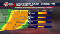
April starts out with a very active and potentially dangerous weather pattern this week. We have activated a Weather Authority Alert for Wednesday for the threat of severe storms. That alert continues Thursday through Saturday for the potential of extreme rainfall and significant flooding impacts.
Wednesday brings another potentially significant severe thunderstorm outbreak. Ingredients for severe storms actually look more favorable than what we saw with Sunday’s system. That setup was rather borderline with respect to wind shear. Wednesday’s setup presents higher shear for rotating storms, combined with ample moisture and enough instability for explosive storm development. All forms of severe impacts are possible, including damaging winds, large hail, and possibly strong / long-track tornadoes. Timing of storms looks to be from mid afternoon into the evening (3PM-10PM). We are currently in a level 3 enhanced risk from the Storm Prediction Center, but they have hinted at the potential for a future upgrade.

Ahead of the storms, it will be a very warm and windy Wednesday afternoon. Some southerly wind gusts of 40-50 mph will be possible.

A risk of severe storms could continue into Thursday, with a level 2 slight risk currently in place for our area. There is still some uncertainty as to the timing and severity of these storms. Thursday’s storm environment will depend to some degree on how Wednesday evening’s storms unfold.

The cold front that will help spark Wednesday’s storms will stall over our area from late Wednesday through Saturday. Multiple rounds of rain and t’storms will develop along this front, resulting in a potentially serious threat for flooding. A Flood Watch is currently in effect for Wednesday evening through Sunday morning. Potentially historic rainfall totals are possible for our area. Widespread 4-day totals of 8-12″ are expected. Some isolated totals of 12-15″ are not out of the question. Even if those totals are on the lower end, there will be the potential for areas of flash flooding. If the more aggressive totals end up occurring, we could see a widespread threat for flash flooding and river flooding, including some areas that do not typically flood having impacts.


